
The vegetation surrounding the Tatlayoko Field Station is exceptionally diverse, a reflection of the region’s highly varied topography and climate.
Vegetation
IDF and SBPS are the principal BGC zones of the Chilcotin Plateau.
Vegetation in the TFS area of interest is exceptionally diverse, a reflection of the region’s highly varied topography and climate, stretching from the Fraser River grasslands in the east, through the dry forests of the Chilcotin plateau, into the high, cold forests in the lee of the Coast Range, ending in the subalpine forests and alpine meadows in the west. Seven of BC’s thirteen forested biogeoclimatic zones are present, as well as all three of the province’s non-forested zones. Described below are some of the vegetation highlights of this remarkable area.


Interior Douglas-Fir (IDF)
The Interior Douglas-fir biogeoclimatic zone extends across much of the southern interior of the province. Some of the driest subzones occur in the Chilcotin. Here a typical site will have Douglas-fir trees of all ages and sizes with a grassy understory in which pinegrass is most common. Wetter and cooler sites, as in riparian areas, will have a dense closed-canopy spruce forest, while at higher elevations or where there has been a recent fire, lodgepole pine will dominate. Trembling aspen occurs throughout the zone, especially in younger forests.
IDFdk (Interior Douglas-fir Dry Cool) is the principal subzone in the Chilcotin, in particular the IDFdk4 variant, which lies on the plateau bordering the valleys of the Chilcotin and Chilanko rivers. It extends from the upper slopes of the river valleys (about 950 m) across the gently rising plateau to about 1150 or 1200 m, where it borders the SBPSxc (Sub-Boreal Pine-Spruce Very Dry Cold). IDFdk4 is the coldest biogeoclimatic unit of the IDF zone and is climatically transitional to the cold, dry SBPS zone. Cold air accumulation areas in the IDFdk4 include lodgepole pine forests that are similar to those on zonal sites in the SBPSxc.
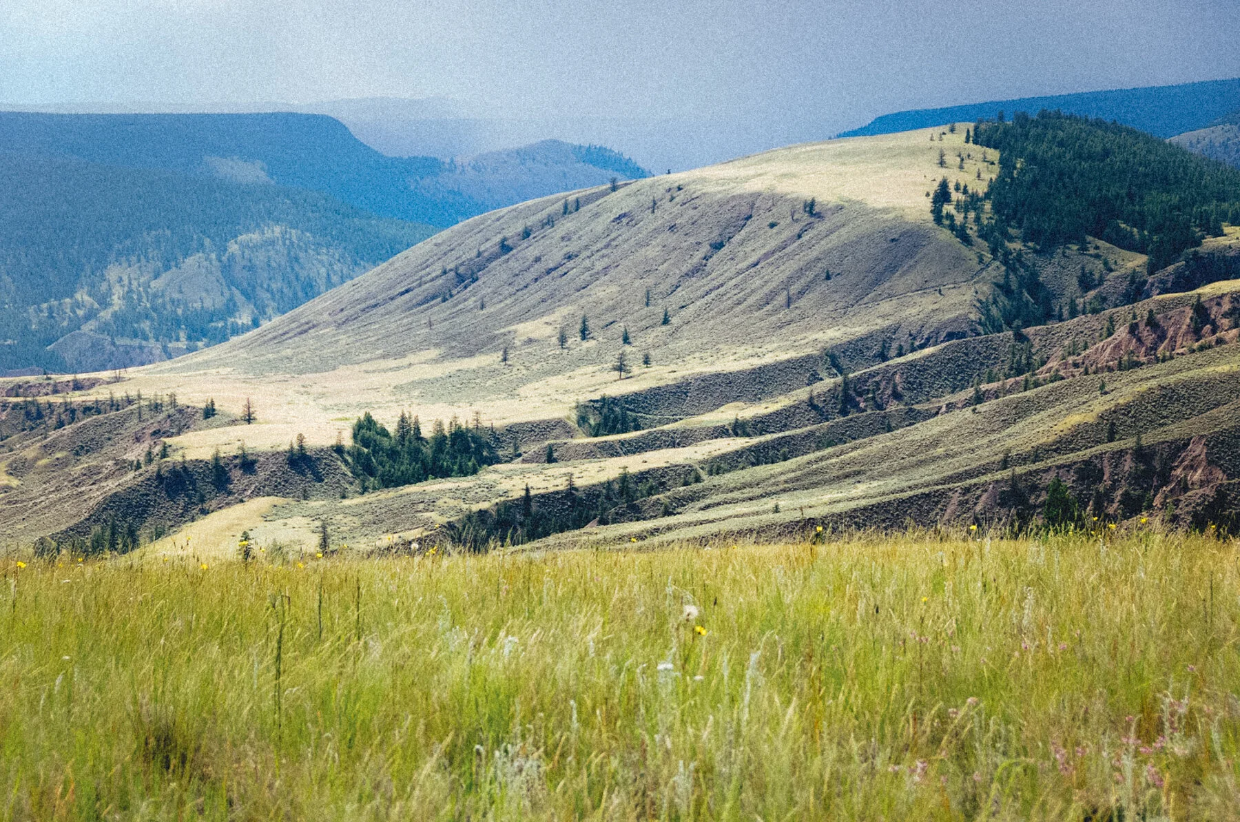
The Tatlayoko Field Station site at Lincoln Creek Ranch is situated within the IDFdw (Interior Douglas-fir Dry Warm) subzone.
As with IDFdk and SBPSxc, understory vegetation is low-growing, creating the characteristic open Chilcotin forest.
IDFdw is a relatively small subzone (1000 km2) occurring only in the broad, low-elevation valleys of the Coast Mountains, primarily those of Chilko Lake, Tatlayoko Lake, Mosley Creek (West Branch), and Klinaklini River. A small area of IDFdw also occurs in the Atnarko and Hotnarko River valleys.
IDFdw occurs in an area of climatic transition. To the north are the dry, strongly interior climates of the IDFdk4, and to the south (down valley) are the IDFww (Interior Douglas-fir Warm Wet) and CWHds (Coastal Western Hemlock Dry Submaritime) climates near the coast.
Douglas-fir dominate the mature forests of IDFdw, but frequent lodgepole pine and occasional subalpine-fir are present. Undergrowth is a moderate cover of shrubs and herbaceous species. Common shrubs are birch-leaved spirea, prickly rose, and soopolallie. Pine-grass is the dominant herbaceous species. The cover of mosses and lichens is sparse.


Sub-Boreal Pine-Spruce (SBPS)
The Sub-Boreal Pine-Spruce biogeoclimatic zone has two principal ecosystems: 1) lodgepole pine forests and 2) wetlands. Small stands of white and black spruce, trembling aspen, Douglas-fir, and black cottonwood add diversity.
Stand-destroying wildfires sweep through SBPS forests regularly, probably on average every 75-125 years. After a fire, new pine seedlings establish quickly. As a result, nearly all SBPS pine stands are even-age, and few are more than 120 years old. On dry sites understory vegetation consists largely of kinnikinnick, common juniper, soopolallie, pinegrass, and lichens.
The wetlands in SBPS commonly form large integrated complexes of many wetland types with islands of upland forest. The boundary line between wetland and dry upland forest is often abrupt. The elevation change between wetland and mesic upland forest may be as little as one metre. Hummocky shrub carrs with low shrub vegetation and saline meadows with salt-tolerant grasses and forbs are often present on wetland peripheries transitional to uplands.
Of other wetland types, sedge and shrub fens developed on deep organic soils are widespread. Marshes with emergent vegetation and shallow water occupy lower-lying sites.
Forested or tall shrub swamps are present in localized areas of high watertable and periodic flooding. Bogs, which occur with elevated surfaces of sphagnum mosses, conifers, and low shrubs, are isolated and rare.
SBPSxc (Sub-Boreal Pine-Spruce Dry Cold) is the largest (approximately 11,000 km2) of the four SBPS subzones. It occupies an arc along the inside of the Coast Mountains where the rainshadow is most pronounced. Vegetation production and soil development are severely limited by the cold, very dry climate.
In SBPS more than 70 species of lichens intermingle in a complex community interlaced with kinnikinnick, small vascular plants, and a few mosses. Nowhere else in BC are so many lichen species as abundant on the forest floor.
Terrestrial and arboreal lichens form the major part of the winter diet of Northern Mountain Caribou. SBPS forests provide critical winter habitat for herds of caribou that spend summers in nearby alpine areas such as those of the Rainbow and Itcha mountains.
The only nesting colony of White Pelicans (Pelecanus erythrorhynchos) in British Columbia occurs on Stum Lake in the SBPS zone. More than 200 pelicans return each spring from California to nest on islands in this lake, from which they fly to surrounding lakes to feed.


Chilcotin Grasslands
Natural grasslands (Bunchgrass biogeoclimatic zone, BG), which are widespread in drier areas of British Columbia’s southern interior, reach northward to the Cariboo-Chilcotin along Fraser River, and westward along lower Chilcotin River valley. This zone represents the northernmost extension in British Columbia of the western Great Basin grasslands. In the east Chilcotin, the Bunchgrass Zone is presently mapped along the Chilcotin River valley west to just upstream of Farwell Canyon; however, the true western extent, based on climate change modelling, may actually now be closer to the Alexis Creek vicinity.
Visit the Centre for Forest Conservation Genetics for an interactive map and data visualization.
Westward in the Chilcotin, at lower (warmer) elevations in the rainshadow of the Coast Mountains, grasslands are interspersed within the Interior Douglas-Fir (IDF) Zone and, to a lesser extent, the higher Sub-boreal Pine–Spruce (SBPS) Zone. As well, the extensive grassland of Becher’s Prairie, just north of Farwell Canyon, is classified within the IDF.
Grassland areas occur on southerly aspects west to Tatla Lake, as well as on isolated slopes along Big Creek, Taseko River, Chilko River, and Homathko River valleys. Climate change models project a substantial expansion of the Bunchgrass Zone in the east Chilcotin and as far westward as Tatla Lake, displacing aspen, Douglas fir, and lodgepole pine forest of the Interior Douglas-Fir Zone.
Although of limited extent in the Chilcotin, grasslands have highly important resource values. Their suitability for livestock grazing – together with wetland and riparian areas for hay production – attracted the first ranchers to the region in the late 19th and early 20th centuries, and they remain vital to the cattle industry. Being in close association with lodgepole pine and Douglas fir forest, aspen copses, wetlands, and riparian areas, grasslands provide habitat diversity for a wide range of species: mammals such as grizzly and black bear, wolves, coyotes, foxes, mule deer, and California bighorn sheep (along Fraser River and lower Chilcotin River); upland song birds and raptors; and waterfowl in adjacent lakes and wetlands (including the red-listed American Pelican).


Wetlands
Wetlands are extensive throughout the Sub-Boreal Pine-Spruce and Montane Spruce Zones of the Chilcotin Plateau. Within the former Chilcotin Forest District, comprising the Central and West Chilcotin and adjacent Coast Mountains, wetlands occupy 91,500 hectares.
Wetlands often occur as complexes of site classes: sedge and shrub fens developed on deep organic soils are most widespread; marshes with emergent vegetation and shallow water occupy lower-lying sites; and forested or tall shrub swamps are present in localized areas of high water table and periodic flooding. Bogs, which occur with elevated surfaces of sphagnum mosses, conifers, and low shrubs, are isolated and rare. Often present on wetland peripheries transitional to uplands, as well as in other low-lying sites, are hummocky shrub carrs with low shrub vegetation, and saline meadows, with salt-tolerant grasses and forbs.

Biogeoclimatic zones of the Tatlayoko Field Station area-of-interest
BLOG POST